Tanjung Priok Port
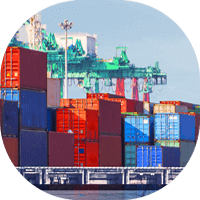
Tanjung Priok Port is the busiest and most advanced port in Indonesia. It is located on the northwest coast of the island of Java, in the province of Banten. Significant towns near Tanjung Priok Port include North Jakarta, West Jakarta, East Jakarta, South Jakarta, and Central Jakarta. The port serves the city of Jakarta and the surrounding region. The port is operated by PT Pelabuhan Indonesia III (Pelindo III).
Tanjung Priok is one of the busiest ports in Southeast Asia. It handles a large variety of cargo, including containers, vehicles, and bulk commodities. The port is also a central hub for passenger ferries.
Tanjung Priok Port has a total area of 2,000 hectares and a quay length of 14 kilometers. The port is capable of handling up to 8 million TEUs per year. It has eight container terminals and one bulk terminal. The port also has a container yard, a ro-ro facility, and a liquid bulk terminal.
Some of the world’s largest container shipping companies, such as Maersk, Cosco, and MSC, operate at Tanjung Priok Port. More than 30 shipping lines serve the port.
In order to export from Tanjung Priok Port, the necessary documents are a bill of lading, commercial invoice, packing list, and certificate of origin. An export license may also be required in some cases. To import into Tanjung Priok Port, the required documents are a bill of lading, commercial invoice, packing list, and certificate of origin. An import license may also need to be obtained in certain situations.
![]() AddressJL.Raya Pelabuhan No.9 Tanjung Priok, Jakarta 14310 Indonesia
AddressJL.Raya Pelabuhan No.9 Tanjung Priok, Jakarta 14310 Indonesia
![]() Port AuthorityIndonesia Port Corp II
Port AuthorityIndonesia Port Corp II
![]() Phone62-21-4367505
Phone62-21-4367505
![]() Fax62-21-4372933
Fax62-21-4372933
![]() Email–
Email–
![]() Coordinates-6º -6′ -3” S, 106º 53′ 27” E
Coordinates-6º -6′ -3” S, 106º 53′ 27” E
![]() Decimal-6.1009636, 106.8910125
Decimal-6.1009636, 106.8910125
![]() UN/LOCODEIDTPP
UN/LOCODEIDTPP
![]() Port TypeSeaport
Port TypeSeaport
![]() Port SizeLarge
Port SizeLarge
![]() Websitewww.priokport.co.id
Websitewww.priokport.co.id
![]() TerminalNo
TerminalNo
Inland port
Mean tide2 feet
Tide
Overhead Limit
Swell
Channel36 – 40 feet 11 – 12.2 meters
Cargo Pier11 – 15 feet 3.4 – 4.6 meters
Mean Tide
Anchorage26 – 30 feet 7.1 – 9.1 meters
Oil Terminal26 – 30 feet 7.1 – 9.1 meters
Harbor SizeLarge
ShelterExcellent
Max Vessel SizeOver 500 feet in length
Harbor TypeCoastal Breakwater
Turning Area
Compulsory
Available
Advisable
Local Assist
Provisions
Fuel Oil
Deck
Water
Diesel Oil
Engine
0-24 Ton Lifts
25-49 Ton Lifts
50-100 Ton Lifts
100+ Ton Lifts
Fixed Cranes
Mobile Cranes
Floating Cranes
Wharves
Med Moor
Ice
Anchor
Beach
Assist
Salvage
Pratique
Deratt Cert
Longshore
Electrical Repair
Steam
Electrical
Navigation Eq
Ship Repairs
Marine Railroad
Drydock Size
Garbage Disposal
Dirty Ballast
Telephone
Radio
Air
Telegraph
Radio Tel
Rail


